


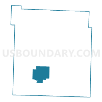
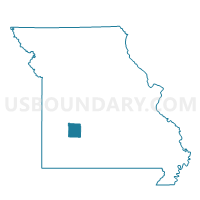
Wishart Voting District, Polk County, Missouri
About
Outline

Summary
| Unique Area Identifier | 609474 |
| Name | Wishart Voting District |
| County | Polk County |
| State | Missouri |
| Area (square miles) | 20.55 |
| Land Area (square miles) | 20.48 |
| Water Area (square miles) | 0.07 |
| % of Land Area | 99.68 |
| % of Water Area | 0.32 |
| Latitude of the Internal Point | 37.52230620 |
| Longtitude of the Internal Point | -93.46237750 |
Maps

Graphs
Select a template below for downloading or customizing gragh for Wishart Voting District, Polk County, Missouri


Neighbors
Neighoring Voting District (by Name) Neighboring Voting District on the Map
- Jackson Voting District, Polk County, MO
- Southwest Marion Voting District, Polk County, MO
- Union Voting District, Polk County, MO
- West Looney Voting District, Polk County, MO
Top 10 Neighboring County Subdivision (by Population) Neighboring County Subdivision on the Map
- Southwest Marion township, Polk County, MO (3,734)
- West Looney township, Polk County, MO (918)
- Jackson township, Polk County, MO (864)
- Wishart township, Polk County, MO (646)
- Union township, Polk County, MO (576)